.png)

Gold Mountain Fire Near Ouray Grows to 25,460 Acres, Highway 550 Remains Closed
Description: The Gold Mountain Fire near Ouray, Colorado, has reached 25,460 acres with 0% containment as crews work to protect Highway 550, nearby communities, and critical infrastructure.
Gold Mountain Fire Update – July 4, 2026
Rocky Mountain Area Complex Incident Management Team 3
Casey Cheesbrough Incident Commander
Fire Information: 970-355-3286 Operational Hours: 8am-8pm
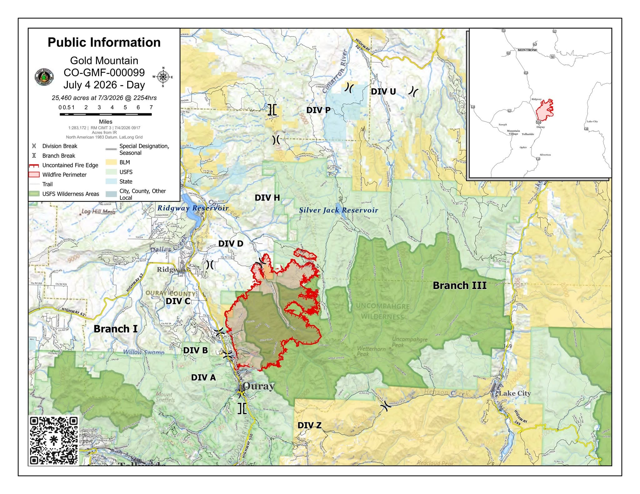
Size: 25,460 acres | Containment: 0% | Cause: Undetermined | Start Date: June 27, 2026 @ 5:33 p.m.
Location: Approx. 2 miles NE of Ouray, CO | Total Personnel: 629
Winds out of the west and red flag conditions on Friday created significant column development. Winds will be lighter with warm temperatures again today. The fire remained active, burning overnight Thursday and throughout the day on Friday, mostly on the east side of the fire. Fire activity decreased on the southwest edge of the fire. The heat and low humidity are promoting favorable conditions for active fire growth. Highway 550 remains closed with a detour between Ridgway and Ouray; speed restrictions and caution barriers are planned to be put in place prior to the highway being reopened. Smoke is visible in the area from both the Gold Mountain Fire and the Ferris Fire to the west.
Current Situation
Southwest fire perimeter just north of Ouray and east of Hwy 550 (Division A): Firefighters will continue protecting the critical values along the Highway 550 corridor from Ouray to Ridgway. They will be utilizing a variety of tactics, including direct fireline and point protection where conditions and fire behavior allow. Crews continue to patrol and mop up the area to prevent the fire from progressing south toward Ouray and to limit fire growth in the Lenore Lake area. The fire edge in the Cutler Creek area continued to back towards the west and down into the Pinon Juniper.
Western fire perimeter east of Hwy 550 (Divisions B and C): Firefighters will utilize direct extinguishment strategies to reinforce and improve the fireline along CR 14A, preventing the fire from progressing west towards Highway 550. Crews continue to assess and prep structures within the Division along the 550 corridor with both day and night operations. The fire continues to burn downslope from Mt. Baldy where crews are working to establish fireline.
Northern fire perimeter between Hwy 550 and Cow Creek (Division D and H): Firefighters are using firing operations along County Road 12 at the D/H division break to keep the fire south of County Road 12. Crews are using masticators to construct a line from Owl Creek to the south while completing structure prep and triage. Structure preparation continues in the Bear Paw subdivision. Firefighters are using firing operations to reduce the fuels and decrease the rate of fire spread. Over the coming days, the Fire has the potential to burn through the Owl Creek saddle and burn into Owl Creek Pass moving north towards Silver Jack Reservoir; movement north may be slow if north winds develop.
North of Silver Jack (Division U and P): Firefighters in High Mesa and Johnson Park areas will scout locations for potential fire lines. The fire continues to burn on the east side of Cow Creek up to the ridge in mixed conifer. Cross slope winds are pushing the fire to the south as well. Crews in this area are also assessing the values at risk ahead of the fire in preparation for suppression and structure protection efforts.
Southeast fire perimeter (Division Z): Crews continue to utilize a variety of tactics to limit fire growth into Bridalveil Creek while implementing point protection measures to reduce impacts to structures and other values at risk.
Evacuations and Closures: For information on evacuations and road closures contact the Ouray County Evacuation Hotline at 970-626-5484 or go to https://ouraycountyco.gov/552/Maps-and-Closures.
The Grand Mesa, Uncompahgre, and Gunnison National Forests issued a Gold Mountain Wildfire Area Closure Order. Learn more at https://www.fs.usda.gov/r02/gmug/alerts.
The BLM Uncompahgre Field Office also issued a partial closure order due to the Gold Mountain Fire. Learn more at https://www.blm.gov/office/uncompahgre-field-office.
Gold Mountain Fire Information
Phone: (970) 355-3286 (8:00 a.m. to 8:00 p.m.)
Email: 2026.goldmountain@firenet.gov
Facebook: www.facebook.com/goldmountainfire
YouTube: www.youtube.com/@goldmountainfire
Montrose County Sheriff's Office
Montrose County Office of Emergency Management
Hinsdale County Office of Emergency Management
U.S. Forest Service-Grand Mesa, Uncompahgre & Gunnison National Forests

Image Gallery