.png)

Gold Mountain Fire Grows to 31,420 Acres Near Ouray; Crews Protect Highway 550 Corridor
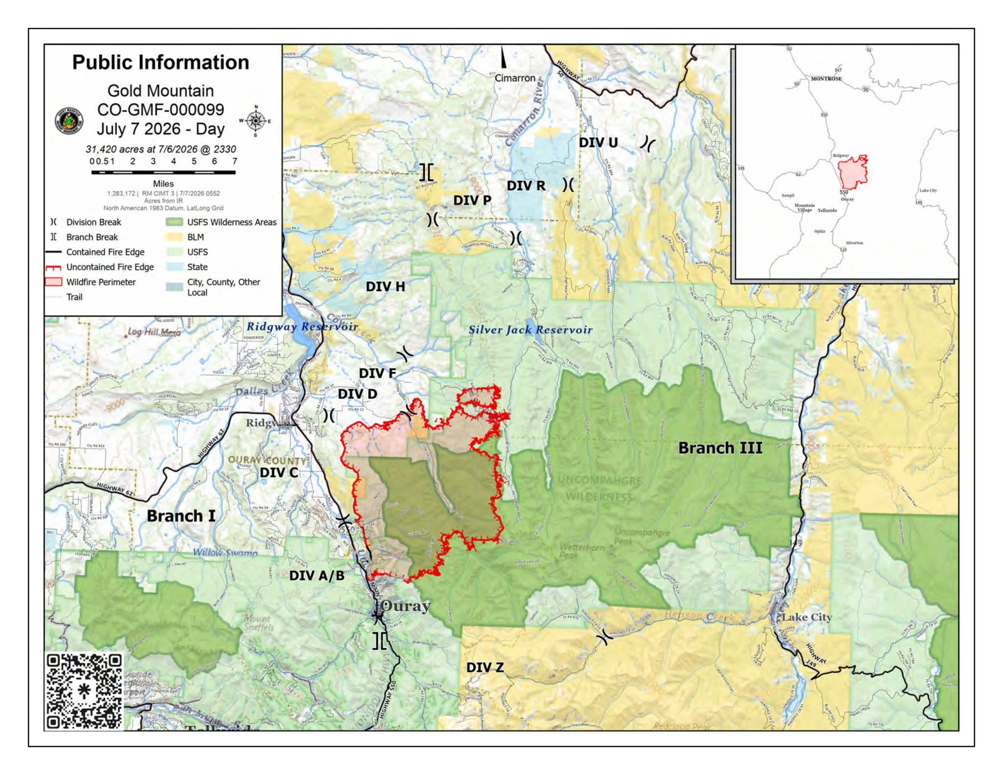
Description: The Gold Mountain Fire near Ouray, Colorado, is 31,420 acres and 2% contained. Firefighters continue structure protection along Highway 550, near Ridgway, Silver Jack Reservoir, Bear Claw, and Silver Jack subdivisions as dry fuels and thunderstorms raise fire concerns.
Gold Mountain Fire Update – July 7, 2026
Size: 31,420 acres | Containment: 2% | Cause: Undetermined | Start Date: June 27, 2026 @ 5:33 p.m.
Location: Approx. 2 miles NE of Ouray, CO | Total Personnel: 928
Firefighters continue the protection of residences and critical infrastructure across the incident area. Crews are preparing and protecting structures by improving defensible space and implementing structure protection measures along the Highway 550 corridor between Ouray and Ridgway as well as around the Silver Jack Reservoir, including the Bear Claw and Silver Jack subdivisions.
Due to the inaccessible rough terrain across the fire area, firefighters are constructing and strengthening indirect containment lines using heavy equipment, natural terrain features, previous cross-boundary fuel treatments, and strategic firing operations where conditions allow. These efforts are designed to slow fire spread while reducing threats to communities and infrastructure. Crews are also scouting and improving additional control lines while also preparing for future firing operations, as needed.
Protecting the Highway 550 corridor remains a top priority. Where containment has been obtained along the southwest portion of the fire, crews continue patrolling completed firelines, extinguishing remaining hot spots, and strengthening suppression efforts near the highway.
The most active fire behavior remains in the northern and northwestern portions of the fire. Strategic firing operations have strengthened containment lines. Additional fire growth is expected along the eastern edge of the fire where some spot fires continue backing downslope into the West Fork of the Cimarron drainage, as the fire moves through steep, heavily forested terrain.
Most of the fire is burning within the Uncompahgre Wilderness Area, where it has not burned in more than 50 years. Heavy dead timber, extremely dry vegetation, prolonged drought, below-average precipitation, and historically low snowpack continue to create conditions that support active fire behavior.
While cooler temperatures, higher humidity, and increased cloud cover may reduce fire activity at times, thunderstorms are expected over the fire area on Tuesday. These storms may bring little rainfall but could produce lightning and strong, unpredictable winds that can quickly change fire behavior.
Unmanned Aircraft Systems (UAS), helicopters, and fixed-wing aircraft continue to support suppression efforts. A Temporary Flight Restriction (TFR) remains in effect over the fire area to ensure these aircraft can safely conduct water and retardant drops. Any unauthorized drone or aircraft entering the TFR forces all firefighting aircraft to immediately stop operations until the airspace is clear. These interruptions delay suppression efforts and place firefighters and the public at greater risk.
Evacuations and Closures: For information on evacuations and road closures contact the Ouray County Evacuation Hotline at 970-626-5484 or go to https://ouraycountyco.gov/552/Maps-and-Closures. The Grand Mesa, Uncompahgre, and Gunnison National Forests issued a Gold Mountain Wildfire Area Closure Order. Learn more at https://www.fs.usda.gov/r02/gmug/alerts. The BLM Uncompahgre Field Office also issued a partial closure order due to the Gold Mountain Fire. Learn more at https://www.blm.gov/office/uncompahgre-field-office.
Montrose County Sheriff's Office
Montrose County Office of Emergency Management
Hinsdale County Office of Emergency Management
U.S. Forest Service-Grand Mesa, Uncompahgre & Gunnison National Forests
Gunnison County Sheriff's Office - Colorado
Gunnison County Emergency Management
San Miguel County Sheriff - Colorado
Ouray County Emergency Management