.png)

Aspen Acres Fire Grows to 97,505 Acres, Reaches 34% Containment as Crews Focus on Western Flank
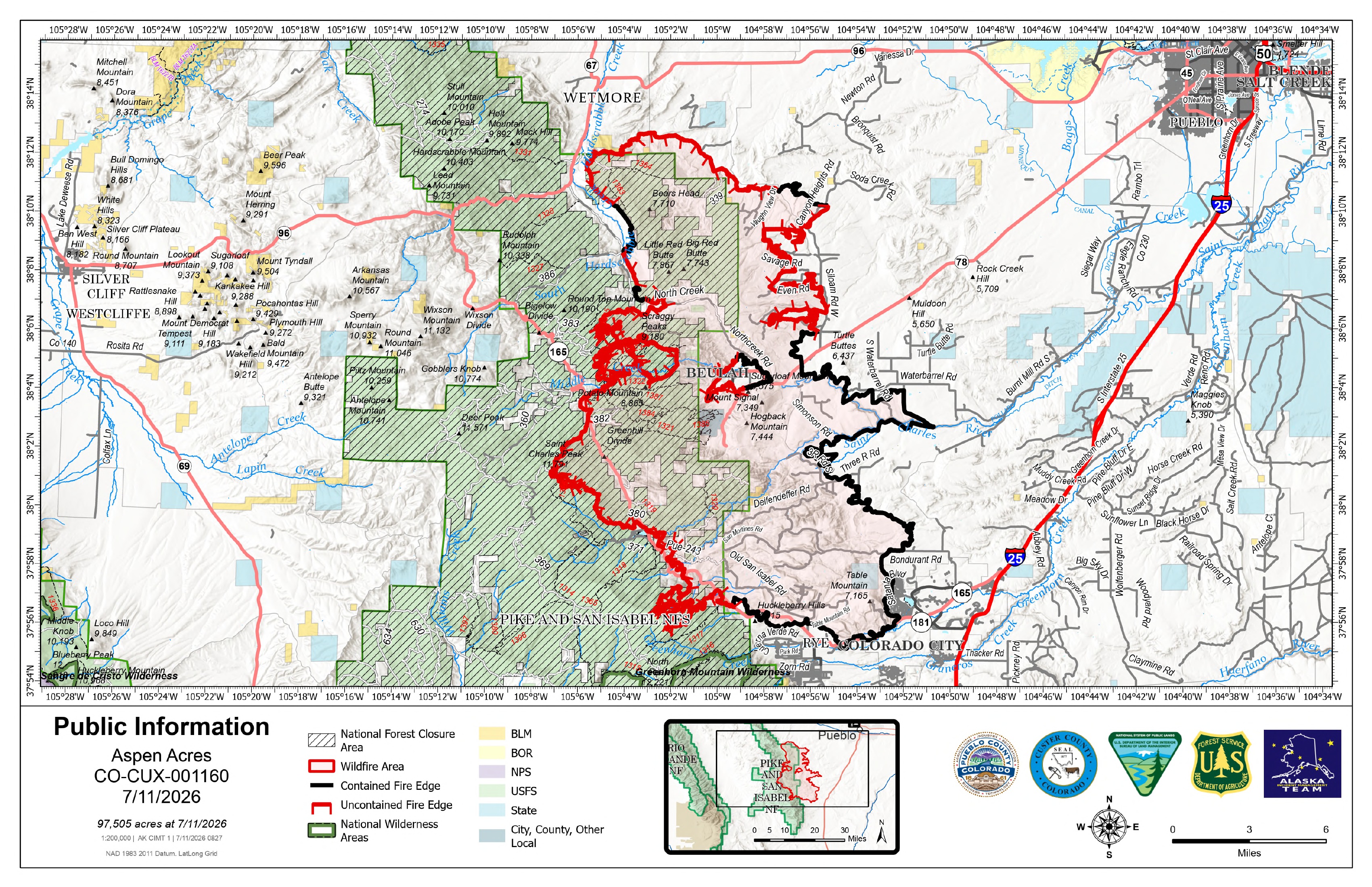
Description: The Aspen Acres Fire reached 97,505 acres and 34% containment July 11 as crews targeted western hot spots and prepared for increased afternoon fire activity...
Aspen Acres Fire Update
Saturday, July 11, 2026 – 8:00 a.m.
Alaska Complex Incident Management Team 1
Jake Livingston, Incident Commander
Size: 97,505 | Containment: 34% | Total Personnel: Approximately 1,921
Location: 10 Miles NW of Rye, CO in Custer and Pueblo Counties
Reported: June 29, 2026, at 6:00 a.m. | Cause: Human, Under Investigation
Fire Information Phone Line: 719.697.8353 | Email: 2026.aspenacres@firenet.gov
Community Meeting: Sheriff Richard Smith is hosting a community meeting for Custer County Residents in Westcliff. It will be held on Sunday, July 12 at 7pm at the Wet Mountain Valley Saddle Club Rodeo Arena, 90 County Road 241. The Alaska Complex Incident Management Team #1 will be supporting Sheriff Smith for the meeting and providing a live broadcast on Facebook.
Fire Update: Crews continue working on the Aspen Acres Fire both day and night. The Friday night shift detected more hot spots near structures and the Mingus Ranch area. They worked through the night cooling those points, reducing threats to communities and homes.
Dozer line construction is progressing on the northwest and southwest sides of the fire area. As conditions permit, crews are burning fuels between the constructed fire line and the wildfire to reduce the probability of fire spotting across the dozer line if the wildfire progresses to the west.
Firefighters continue to patrol the eastern side of the fire, checking for hot spots, working on interior sections of the fire, and providing structure protection. Crews and resources are transitioning to the west and southwest side of the fire on Friday as containment on the east side of the fire increases.
Firefighting aircraft provided critical support to operations on Friday. To the west of Rye, helicopters with water-scooping buckets were intensively used, as well as fixed-wing aircraft that dropped retardant to slow the fire spread. The west side of the fire continues to challenge firefighters in rugged terrain and fuels highly susceptible to ignition. Another day of intense air support is planned for Saturday.
Uncrewed aircraft with heat detection capabilities are being used to efficiently direct firefighting resources on the ground to target areas with remaining heat. Little heat was detected in the vicinity of Beulah on Friday, but work remains on containment line to protect the community from potential flare-ups in the interior of the fire area. The Aspen Acres area has also cooled, but hot spots were detected and targeted near Bishop Castle.
Weather: The fire area was dry and windy on Friday. Saturday is forecast to be hot and dry, with light winds and low humidity. A chance of afternoon thunderstorms persists. A high pressure system is expected to build in the region next week.
Fire Behavior: As temperatures and winds increased on Friday afternoon, fire activity again increased on the west side in the vicinity of North Muddy Creek, south of San Isabel and north of Rye. Fuels in this area will remain receptive to fire on Saturday, with an anticipated uptick in activity again in the afternoon.
Fire Restrictions & Closures: There is an Aspen Acres Fire Area Closure for the San Carlos Ranger District. Visit: https://www.fs.usda.gov/r02/psicc/alerts/aspen-acres-fire-area-closure. Please monitor land managing agencies for other fire restrictions.
Evacuations: Evacuations and pre-evacuations are in place across Custer, Pueblo, Fremont, and Huerfano Counties. Please call the Joint Information Center (JIC) at 719-583-4640 for information about closures, evacuations, Disaster Assistance Center (DAC) information, and more for Pueblo and Custer Counties. Huerfano and Fremont County residents should visit their county's social media pages or call 719-738-1044 for Huerfano County dispatch and 719-276-7421 for the Fremont County Emergency Operations Center.
There is a Temporary Flight Restriction (TFR) in place above the fire area. Flying any aircraft within the TFR is prohibited. This includes the use of drones, or unmanned aerial systems.
Air Quality: An Air Resource Advisor is assigned to the incident and assessing where communities may be impacted by smoke. To get daily air quality information, visit https://fire.airnow.gov/
The public and members of the media should monitor the following official websites:
Follow Pueblo County Sheriff's Office Facebook at www.facebook.com/PuebloSheriff and X: @PuebloCountySO https://x.com/PuebloCountySO.
Follow Custer County Sheriff's Office Facebook at https://www.facebook.com/CCSOAdmin.

Image Gallery
_page_1.jpg)
_page_1.jpg)
_page_2.jpg)